BeiDou Science Database

Introduction
BeiDou Science Database mainly brings together BeiDou/GNSS high-quality raw observation data and precise products from important projects such as the international GNSS Monitoring and Assessment System (iGMAS), and provides services for nationwide scientific research and education users who have precision requirements for satellite navigation, positioning and time service in the fields such as time frequency, mapping, earthquake, meteorology, traffic, space physics, communication and electric power.
BeiDou Science Database is established based on the platforms such as iGMAS data center, analysis center and tracking station of the National Time Service Center of the Chinese Academy of Sciences. iGMAS is initiated and built by China, and has the main tasks of establishing a global real-time tracking network for the full-arc and multi-coverage observation of the world's major satellite navigation systems, such as BeiDou/GPS/GLONASS/Galileo and an information platform with the functions such as data acquisition, storage, analysis, management and release. iGMAS detects and evaluates the operating status and main indicators of global satellite navigation systems, generates the high precision products such as ephemeris, satellite clock error, earth orientation parameters, tracking station coordinates and rates, and global ionospheric delay, supports satellite navigation technical test, monitoring and evaluation, and serves scientific research and various applications.
Service Modes
BeiDou Science Database provides data services in three modes: FTP downloading service, FTP data pushing service and order offline service.
The FTP server address is: ftp://igmas.ntsc.ac.cn. BeiDou/GNSS precise products can be accessed anonymously, but raw observation data needs to be obtained after logging in or ordering. When accessed, the FTP server shall be set to the active mode.
Data Resource
Raw Observation Data
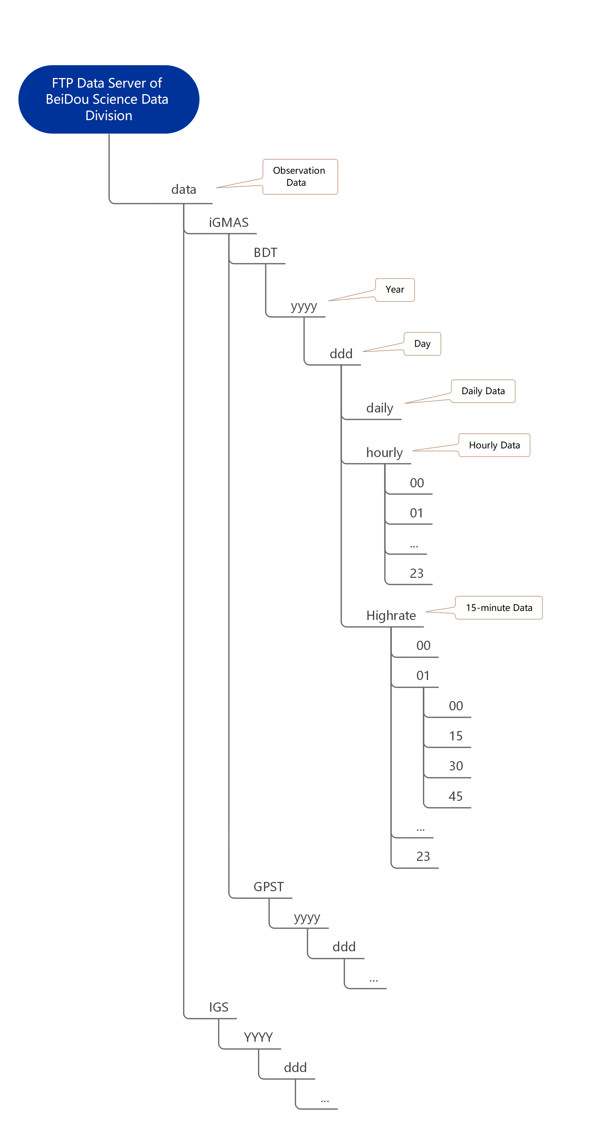
BeiDou Science Database can provide users with raw observation data of BDS, GPS, GLONASS and Galileo system from tracking stations, navigation ephemeris and station meteorological data. The observation data stored by the FTP data server of BeiDou Science Database can be divided into BeiDou time and GPS time data according to the system time used in the data, and into daily, hourly and 15-minute data according to the update interval. On this basis, the directory is divided by year and day of year.
The directory structure is shown in Figure 1. In which, "yyyy" is a year represented by four digits, "ddd" is a day of year represented by three digits, "daily" represents a file that stores the observation data of one day, "hourly" represents a file that stores the observation data of one hour, and "highrate" represents a file that stores the observation data of 15 minutes.
Precise Products
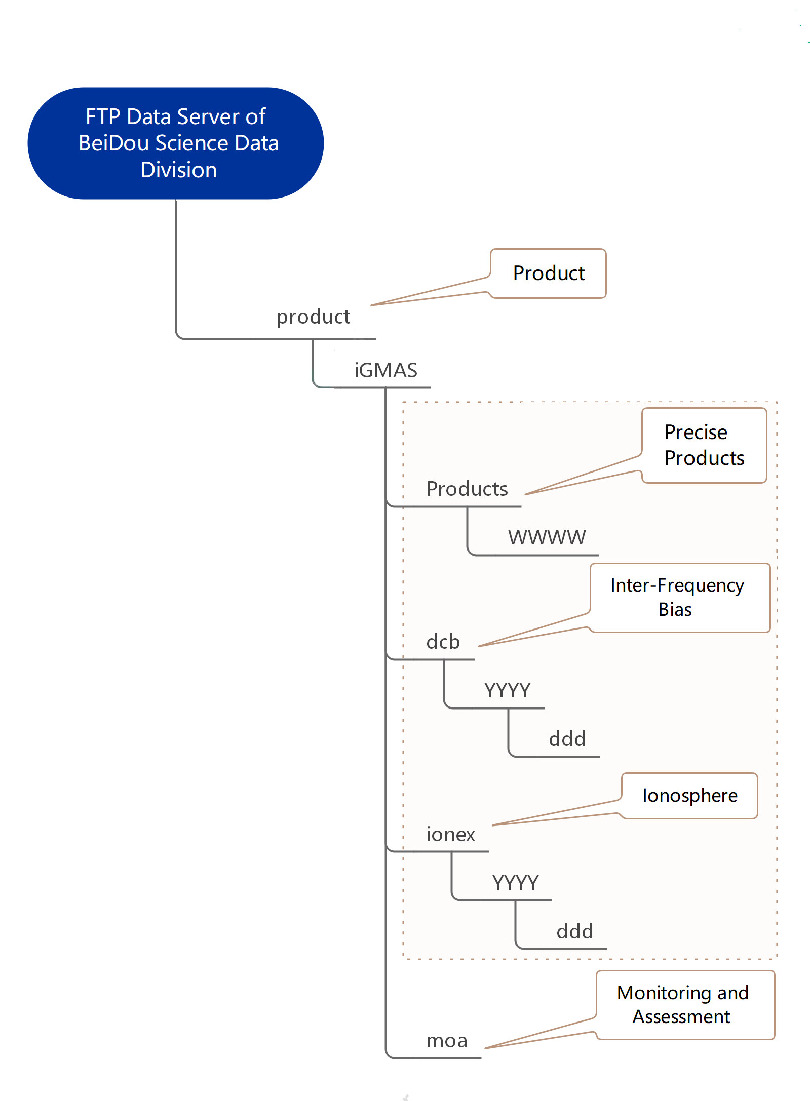
BeiDou Science Database can provide users with the products such as satellite orbit of BDS, GPS, GLONASS and Galileo system, satellite station clock error, earth rotation parameters, troposphere, ionosphere and station coordinates. The products stored by the FTP data server are divided in the directory according to the precise products (including orbit, clock error, troposphere, earth rotation parameters and station coordinates), ionosphere products, inter-frequency bias parameter products, and monitoring and evaluation parameter products.
The directory structure is shown in Figure 2. In which, the "products" directory stores the precise products, the "ionex" directory stores the ionosphere products, the "dcb" directory stores the inter-frequency bias parameter products, and the "moa" directory stores the monitoring and evaluation parameter products. BDS-3 B1IB3I satellite orbit products (with the time scale being BeiDou time) are located in the "b1ib3i" directory under "BDS Week" directory of the "products" directory.
Time Service Application
Based on the software, hardware and data resources of BeiDou Science Database, a prototype BeiDou subnanosecond precise time service system based on national standard time UTC(NTSC) has been established. With the help of the prototype system, users can obtain the national standard time UTC(NTSC) with a subnanosecond precision in real-time through a variety of technical means such as Precise Point Positioning (PPP), Carrier Phase Common View (PCV) and Real-Time Kinematic (RTK).
Some tracking stations with external high performance atomic clocks are selected to continuously monitor the performance of BeiDou subnanosecond precise time service online. This page displays the real-time calculation results (the time differences between the local time of monitoring station and the national standard time UTC(NTSC), which are not calibrated) of each monitoring station based on BeiDou Precise Time Service client software in the last 24 hours. It is updated every hour on a rolling basis.
Site
Precision Time Service Performance Monitoring(Jilin)
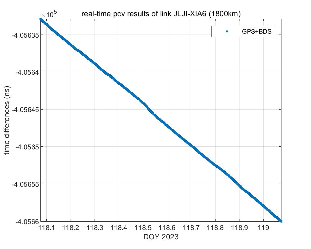
- Station: JLJI (Jilin, China)
- Base length: 1800km
- Calculation Mode: PCV
- raw observation data: BeiDou+GPS
- Product: iGMAS Ultrafast Orbit
Precision Time Service Performance Monitoring(Sanya)
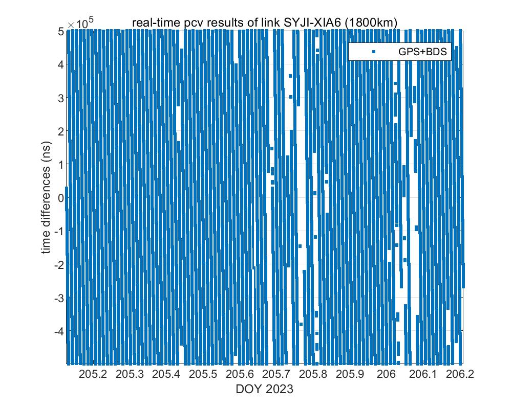
- Station: SYJI (Sanya, China)
- Base length: 1800km
- Calculation Mode: PCV
- raw observation data: BeiDou+GPS
- Product: iGMAS Ultrafast Orbit