China-Brazil Joint Laboratory for Space Weather/Laboratory for Space Weather in South America, Chinese Academy of Sciences
The China-Brazil Joint Laboratory for Space Weather (hereinafter referred to as CBJLSW), also known as the CAS Laboratory for Space Weather in South America, is the first overseas scientific and educational base of the Chinese Academy of Sciences (CAS), which is jointly established through international cooperation by the National Space Science Center (NSSC) of CAS and the National Institute for Space Research (INPE) in Brazil. It is the first comprehensive observation and research platform for solar-terrestrial space environment in South America.
The CBJLSW aims to carry out joint observations and data pooling of the meridian chain of the solar-terrestrial space environment in the western hemisphere, joint exploration and research of the solar-terrestrial space environment in the low latitudes of the eastern and western hemispheres, as well as personnel training, to build the basic framework of the International Meridian Circle Program, and to serve as a bridge and link for cultural exchanges between China and Brazil.
In the first 5 years of the initial construction and operation period of CBJLSW, the organizational structure, infrastructure, data center, and deployment of Middle and upper atmospheric and ionospheric monitoring equipment (Ionospheric vertical sounding, GPS TEC and scintillation monitor, and Doppler wind measurement lidar) will be completed. The second 5-year period will witness an expansion of construction and improvement of operation, which will further optimize the operation mechanism of the lab and deploy more powerful middle and upper atmosphere and ionosphere monitoring equipment (e.g. VHF high frequency radar, all-solid state high altitude wind and temperature measurement lidar, etc.).
| No. | Instrucment | Objective | Indicators |
|---|---|---|---|
| 1. | Sodium-potassium dual-wavelength lidar | The atmospheric backscattered echo signals from near the ground to 110 km are obtained, and atmospheric parameters such as density, temperature, sodium layer density, and potassium layer density of the middle and upper atmosphere of the geospace environment can be obtained by inversion. | Atmospheric density Detection altitude range: 30~70km Altitude resolution: 24~96m Time resolution: 5 minutes Atmospheric temperature Detection altitude range:30~70km Altitude resolution:15~300m Time resolution: 2 hours Atmospheric sodium atomic number density Detection altitude range: 80~110km Altitude resolution:15~600m Time resolution: 5 minutes Atmospheric potassium atomic number density Detection altitude range: 80~110km Altitude resolution:15~600m Time resolution: 5 minutes |
| 2. | All-sky airglow imager | Acquisition of airglow radiation intensity data between 85 and 250 km altitude. | Achieve the observation of the following airglow wavelengths (wavelength (nm) ± FWHM
(nm)) 1. 557.7±2.0 2. 589.3±2.0 3. 630.0±2.0 4. 656.3±2.0 5. 777.4±2.0 6. 865.0 ±10 7. 715.0 ±10.0nm & 930.0±10.0nm, Notch865.5nm±18nm |
| 3. | Digisonde | By transmitting radio pulses vertically upward and receiving echoes from the ionosphere at different frequencies, the propagation time of the echoes is measured and the variation curve of the reflected virtual height with frequency is obtained. On this basis, the critical frequency foF2, the peak height of the ionosphere, and the maximum electron density value NmF2 of the ionosphere can be obtained, and the ionospheric electron concentration profile under the peak can be inverted. | Receiver Frequency range: 1~30MHZ Bandwidth (6dB point): 20KHz Sensitivity: -120dB Dynamic range: 70dB Gain control: automatic or manual selectable Transmitting Antenna Frequency range: 1~30MHZ Bandwidth (6dB point): 20KHz Receiving Antenna Frequency range: 1~30MHZ Bandwidth (6dB point): 20KHz |
| 4. | GPS-TEC | Monitoring of ionospheric morphology-disturbance-effects near 120°E, and ionospheric parameters such as ionospheric scintillation at mid and low latitudes. | 1. Measurement accuracy Phase noise requirement of this crystal: -125dBc/Hz@10Hz, -145dBc/Hz@100Hz, -165dBc/Hz@10000Hz ● L1 C/A Code 6 cm RMS ● L1 Carrier Phase 0.75 mm RMS ● L2 P(Y) Code 25 cm RMS L2 Carrier Phase 2 mm RMS ● L2 Carrier Phase 2 mm RMS 2. Time accuracy: 20 ns RMS. 3. 3. communication interface: RS-232/USB, rate: 230400bps/5Mbps. 4. Receiving antenna: dual-band ergodic anti-jamming antenna. 5. feed line: 15m. 6. power supply 9V to 15V, power: 5W. 7. operating ambient temperature -40℃~70℃. 8. absolute TEC measurement accuracy: less than 2TECU 9. relative TEC measurement accuracy: less than 0.02TECU. 10. S4 measurement accuracy: 0.01. |
| 5. | Atmospheric electric field Monitor | 1-fraction atmospheric electric field | Dynamic range: -20kV/m~+20kV/m Panel display resolution: ≤2.5V/m Computer acquisition resolution: ≤ 5V/m Frequency band range: DC~ 1Hz Linearity coefficient: ≤0.5% Panel display sampling rate: 2.5 times/s Computer acquisition resolution: ≥ 5 times / s GPS time service: GPS real-time time acquisition Overall power consumption: less than 30W |
| 6. | Magnetic fluxgate magnetometer | The 3-component geomagnetic relative variation fields H, D, Z and temperature T are monitored. | Measurement components: H, Z, D geomagnetic field tri-component and temperature T. Measurement range: 0 to ±62,500 nT. Dynamic range: 0 to ±2,500 nT. Discrimination: 0.1 nT. Noise level: less than 0.1 nT RMS. Temperature coefficient: less than 1 nT/°C. Nonlinearity: better than 5‰. Frequency band width: 0 to 0.3 Hz. A/D analog-to-digital conversion: 24 bits. Sample rate: 1 time/sec. Data storage: 512MB CF memory card. Communication interface: 10M Ethernet interface. Timing mode: 0.5ppm timekeeping, GPS timing. Timing accuracy: less than 1s/day; (GPS effective) Overall power consumption: average power consumption <4W. Operating temperature: 0℃~+40℃ |
| 7. | Dual-frequency Dual-polarized Doppler Solid-state Radar,D3SR | Non-precipitating clouds, weak precipitating clouds, stratiform precipitation, and convective precipitation during the evolution of cloud and precipitation | Ka-band Continuous operation time: 24 hours one day Frequency: 34.035 GHz Detection capability: -38.4 dBz (30m resolution) Range resolution: 10m, 30m Range: 30m ~ 30km Azimuth angle: 0~360° Elevation range: 0~180° Noise figure: 3.6 dB Output parameters: Reflectivity, radial velocity, spectrum width, differential reflectivity, differential propagation phase shift, specific differential phase shift, correlation coefficient, signal-to-noise ratio, etc. X-band Continuous operation time: 24 hours a day Frequency: 9.415 GHz Detection capability: -24 dBZ @ 10km (120m resolution) Range resolution: 30m, 60m, 120m Range: 60m ~ 150km Azimuth angle: 0~360° Elevation range: 0~180° Noise figure: 2.2 dB Output parameters: Reflectivity, radial velocity, spectrum width, differential reflectivity, differential propagation phase shift, specific differential phase shift, correlation coefficient, signal-to-noise ratio, etc. |
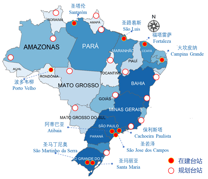
| Station | Latitude | Longitude | Content | |
|---|---|---|---|---|
| City | State | |||
| São Jose dos Campos | São Paulo | 23°10'46"S | 45°53'13"W | Sodium-potassium dual-wavelength lidar、GNSS、Atmospheric electric field Monitor |
| Cachoeira Paulista | São Paulo | 22°39'54"S | 45°00'34"W | Data Center |
| Santa Maria | Rio Grande do Sul | 29°41'03"S | 53°48'25"W | Digisonde、GPS-TEC、Millimeter wave cloud measurement radar |
| São Martinho da Serra | Rio Grande do Sul | 29° 32' 05'' S | 53° 51' 42'' W | Magnetic fluxgate magnetometer、All-sky airglow imager |
| Atibaia | São Paulo | 23º05'29" S | 46º54'28" W | Atmospheric electric field Monitor、Magnetic fluxgate magnetometer |
| Campina Grande | Praiba | 02°31'47"S | 44°18'10"W | Digisonde、Atmospheric electric field Monitor |
| Porto Velho | Londonia | 01°27'21"S | 48°30'16"W | GNSS |
| São Luiz | Mananhão | 02°31'47"S | 44°18'10"W | Magnetic fluxgate magnetometer |
| Fortaleza | Ceará | 03°43'02"S | 38°32'35"W | Magnetic fluxgate magnetometer |
| Santarém | Pará | 54°42'03"W | 02°27'02” N | GNSS、Magnetic fluxgate magnetometer |